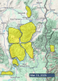
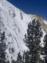
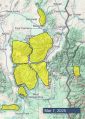
Advisory Archive
Snow totals over the last 24 hours are:
- 4-6” in Cooke City, West Yellowstone and Island Park.
- 2-3” in the Bridger Range, Big Sky and Taylor Fork.
- Zero in Hyalite.
Wind increased overnight out of the southwest and west at 15-25 mph with gusts of 35-50 mph. Strong west and southwest winds will continue today and tonight. Temperatures are single digits to low 20s F and will reach 20s to 30s F today.
Snowfall is expected today through tomorrow, picking up in intensity mid-day. The mountains near West Yellowstone, Island Park and Cooke City are favoreds with 7-12” possible by this evening and 12-24” possible by tomorrow morning. Near Bozeman and Big Sky should receive 5-8” by morning with more throughout the forecast area tomorrow.


This morning there are snow showers in the mountains, and since yesterday there has been:
- 4” of new snow near Island Park and Big Sky,
- 1-2” near West Yellowstone and Cooke City
- and a trace to 1” near Bozeman.
Temperatures are single digits to teens F. Wind has been from the west and southwest, and generally calm to light at 5-15 mph with a few hours last night of speeds to 20 mph with gusts to 35 mph.
Today, temperatures will reach 20s to 30 F, and wind will be out of the west and southwest increasing to 10-20 mph with gusts to 30 mph. Snow showers are possible tonight, with 1-3” by tomorrow morning, and more snow is expected tomorrow afternoon through Tuesday morning.

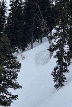
There are generally 5-8” of new snow (0.4-0.9” Snow Water Equivalent) across the advisory area, with up to 10” at one snow sensor near Big Sky. Winds dropped off yesterday as the cold front moved through and are blowing 10-20 mph out of the southwest to northwest this morning, with gusts of 20-40 mph. Temperatures are in the teens and 20s F.
Snowfall has mostly wrapped up early this morning. Snow showers today and tonight will only leave a dusting in most places, but there may be spots that see up to 2” by tomorrow morning. Winds today will be out of the west and southwest at 10-20 mph. Mostly cloudy skies this morning will likely clear this afternoon around Bozeman and Big Sky, while staying cloudy elsewhere. High temperatures will be in the 20s and low 30s F.
This morning snowfall has already started near Island Park, West Yellowstone and Big Sky with a trace to 1” accumulating so far. Strong winds from the south continue blowing 20-40 mph gusting 50-60 mph, except in the Bridgers and near Cooke City where winds are a bit lighter. Temperatures are in the mid 20s F in most areas while in the Bridgers temperatures are in the low 30s F.
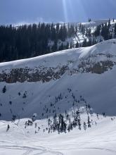
Today a deep trough will move across California and Nevada with our forecast area on the front edge of this system. The Centennial Range near Island Park will take the brunt of the storm with heavy snowfall and strong south winds continuing to gust 50-60 mph. By afternoon, winds will decrease significantly and precipitation should finally reach the Bozeman area. Temperatures will remain steady this morning before dropping late today when a cold front arrives.
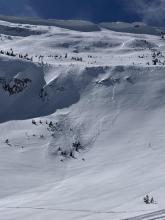
Snow totals by tomorrow morning should be: 12-18” near Island Park, 6-12” near West Yellowstone, 6-8” near Big Sky, 4-6” near Bozeman and Cooke City. Lighter snowfall will continue tomorrow with a break this weekend before the next system brings snow and strong winds Sunday-Tuesday followed by even more snow later in the week.
Strong winds with snow coming late tomorrow is the main weather story. Winds yesterday averaged 25-35 mph gusting to 50 from the west and southwest. They eased a little this morning but will be picking up again today similar to yesterday except coming more from the south.
Temperatures today are starting in the mid-20s F and will warm into the upper 20s to low 30s F depending on cloud cover which will be increasing through the day.
Snow arrives tomorrow but mostly falls tomorrow night. Many mountain locations will get 3-5 inches with the most snow falling near West Yellowstone and Island Park. By Friday morning, the Centennial Range could have 12-24 inches. Strong winds continue Thursday but should be lighter Friday and Saturday before they ramp up again.
But wait, there’s more! For the next week or two, the weather will remain quite active with snow and wind and a series of low pressure troughs (aka storms) lined up to roll across the area.


This morning, temperatures are in the high teens to 30 F, with 15-35 mph winds from the west and southwest. There is no new snow.
Today, temperatures will be in the 30s to low-40s F, with 15-30 mph winds from the west and southwest. Snow returns to the area Wednesday night.


This morning, temperatures are in the 20s to low-30s F, with 15-40 mph winds from the west and southwest. There is no new snow.
Today, temperatures will be in the 30s to low-40s F, with 15-40 mph winds from the west and southwest and increasing clouds throughout the day. There is a chance for a trace of new snow later today, but the next significant snowstorm moves into the area on Wednesday afternoon.
This morning, under mostly clear skies, temperatures are teens to low 30s F, and wind is out of the west at 5-15 mph with gusts to 35 mph.
Today, temperatures will reach high 30s to low 40s F under mostly sunny skies, and wind will remain light to moderate from the west and southwest at 5-15 mph with gusts to 35 mph.
Over the next few days cloud cover will increase with slightly cooler temperatures. Tomorrow night there is a chance for light snow showers with more snow possible late Wednesday through next weekend.


It’s going to be another beautiful, warm spring day.
This morning, temperatures are in the teens F. Winds are 10-20 mph out of the west. There are a mixture of high clouds and blue skies and no new snow.
Today, high temperatures will rise into the 30s and low 40s F. Winds will continue at 10-20 mph out of the west. Expect a mixture of sun and clouds. No new snow is expected until early next week, at the earliest.
Snow totals in the last 24 hours are:
5-6” near Bozeman
3-5” near Big Sky and the Taylor Fork
5” near Island Park
2” in the Lionhead area
1” near Cooke City
Winds have generally been out of the north and east at 5-10 mph with 15-25 mph gusts. In the Bridger Range, winds blew out of the east yesterday at 35 mph with 55 mph gusts, but early this morning dropped dramatically and shifted to the northwest. Temperatures are in the single digits and teens F.
Winds today will be light, shifting to the north and northwest by this afternoon. Temperatures will rise into the 20s and low 30s F. Skies will be mostly sunny.
The next chance for snowfall is early next week.