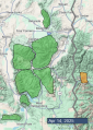
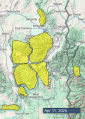
Advisory Archive

This morning, temperatures are near 30 degrees F with 5-15 mph winds from the west and southwest. Clear skies overnight allowed longwave radiation to escape into the atmosphere and snow surfaces to refreeze.
Today, temperatures will be 10 degrees F warmer than yesterday, with highs nearing 50 F in Cooke City and rising well into the 50s F across the rest of the forecast area. Winds will be 5-15 mph from the west and southwest. A few clouds will move into the area this evening, but the change in weather arrives tomorrow afternoon when low pressure arrives from Canada and with it, colder temperatures and a chance for more than a foot of new snow.
This morning, temperatures are in the teens to low 20s F with light winds blowing 5-15 mph from the west and the north. The Bridger and northern Gallatin Ranges picked up 2” of additional snow yesterday morning before the weekend’s storm moved out of the area.
Today and tomorrow will have similar weather, with clear skies, above-average temperatures, and dry conditions. Today, temperatures will be in the 40s to 50 degrees F, with 5-10 mph winds from the northwest shifting to the southwest.
Later this week, an upper-level trough will move south from Canada, bringing colder temperatures and snow to Southwest Montana and Island Park late Wednesday through Thursday. This will be followed by a weekend warm-up and another storm early next week.
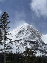

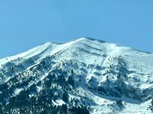
Classic spring weather yesterday afternoon delivered snow in the mountains and rain in the valleys accompanied by lightning and thunder.
- 10” snow (1.1” water) - Cooke City Area
- 6” snow (0.8” water) - northern Gallatin Range
- 2-3” snow (0.2-0.3” water) - Bridger Range and Big Sky area
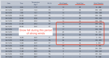
Temperatures plummeted overnight and range from around 20° F in the Bridgers to low-mid teens F most other places to single digits F at the highest elevations. Strong ridgetop winds during snowfall yesterday blew 20 mph gusting 40-50 changing directions quickly from S to W to NW. Winds have eased this morning.
Today cold air and lingering clouds will remain over the area with a few snowflakes falling in the Bridgers. The sun should start peeking out this afternoon bringing high temps into the mid 30s F in the Bridgers and low to mid 20s F near Big Sky and Cooke City. There will be clear skies and plenty of sunshine near West Yellowstone and Island Park with high temps approaching 30° F. Winds from the WNW will blow in the low teens but could remain a bit gusty in the Bridgers.
Looking ahead - A ridge of high pressure brings warm, dry weather Monday & Tuesday. Another trough descends from Canada bringing more snow and cold air on Thursday. The fight between winter and summer continues.

The tug of war between winter and summer continues. Following high temperatures yesterday in the 40s and 50s F, overnight air temps stayed above freezing only dropping into the upper 30s F. Cloudy skies overnight likely prevented any radiational refreezing of the snowpack. Light winds this morning are coming from the southwest
An approaching trough of low pressure will bring a little bit of everything in today’s weather. Temperatures should warm to either side of 40° F this morning before cooling this afternoon when a cold front finally passes overhead bringing cold air by the end of the day.
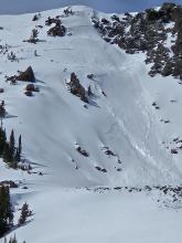
Winds will increase this afternoon blowing 15-20 mph gusting in the 30s mostly from the southwest but switching to the west-northwest in the mountains near Bozeman. Cloudy skies will be spitting rain and snow (mostly snow in the mountains) this morning. A bit more snow should fall this afternoon with most areas receiving an inch or so. A few places like maybe near Cooke City and the northern Gallatin Range could get 2-4 inches by tonight, but your guess is as good as mine.
Temperatures did not drop below freezing last night. Early this morning, they are in the high 30s and low 40s F. There has not been any measurable rain or snow. Winds are out of the south and west at 10-25 mph, with gusts as high as 50 mph.
High temperatures today will be in the 40s and 50s F. Skies will start off mostly sunny this morning, with increasing clouds around Bozeman and Big Sky this afternoon. Winds will remain moderate out of the south and west.
Rain and snow showers will start overnight. Temperatures will be cooler this weekend and precipitation will continue, on and off, but accumulations are looking modest at this point.

This morning there is no new snow and temperatures are high 20s to low 30s F. Wind is out of the west at 10-20 mph with gusts to 30 mph. Yesterday afternoon winds were moderate to strong out of the west and northwest, averaging 15-35 mph with gusts reaching 50-65 mph.
Today, skies will be mostly sunny with temperatures reaching mid-40s to mid-50s F, and light to moderate wind out of the west-southwest at 10-25 mph. Tonight temperatures will drop to mid-30s and low 40s F under partly to mostly clear skies.
Tomorrow will be similarly warm and sunny before cooler, wet and snowy weather arrives Friday night through Sunday morning.


Yesterday’s storm delivered more than expected with snow above ~7,000’ and a mix of rain and snow at lower elevations. Since precipitation began early yesterday, total snow water equivalent (SWE) amounts and estimated snow depths are:
- 0.9-1.0” SWE with 4-9” snow near Island Park and West Yellowstone.
- 0.3-0.5” SWE with 3-5” snow in the Taylor Fork, Big Sky, Hyalite, Bridger Range and Cooke City.
This morning, temperatures are low 20s to low 30s F, and wind is out of the west and northwest at 10-20 mph with gusts of 20-40 mph.
Today, under clearing skies, temperatures will reach mid-30s to mid-40s F, and this afternoon westerly winds will increase to 15-25 mph with gusts of 30-45 mph.
The next couple days look mostly clear and sunny with daytime temperatures reaching high 40s to mid-50s F and overnight lows in the 30s F. This weekend will have cooler temperatures with a chance for heavy snowfall.
There is a spring mix of weather in the mountains this morning, with temperatures just above and below the freezing line, some rain, some snow and winds blowing 15-30 mph from the west and southwest. There is an inch of new snow in the mountains around Bozeman, Big Sky, West Yellowstone and Island Park. However, in the mountains around West Yellowstone and Island Park precipitation started as rain.
Today, high temperatures will be in the 30s and 40s F, with light snow or rain depending where you are relative to the 6000-7500’ elevation freezing line. Winds will be 10-20 mph from the west and southwest, and the mountains may get another 1-2 inches of snow throughout the day. Sun and warm temperatures return tomorrow.
This morning, mountain temperatures mostly dropped below freezing and are hovering in the upper 20s to low 30s F. Winds are 10-20 mph from the west and the south, and there is no new snow.
Today, the ridge of high pressure breaks down and increasing clouds will start to shade slopes from the constant spring sun. Temperatures in the Bridger Range will peak in the mid-50s F with highs in the mid-40s F throughout the rest of the forecast area. Winds will blow 10-20 mph from the west and southwest, and light snowfall starting tonight will bring 1-2” in the southern portions of the forecast area and a trace to the northern half of the forecast area by morning.

This morning temperatures are high teens to low 30s F. Wind has been from the southwest and northwest at 5-25 mph with gusts of 25-35 mph. There has been no new snow over the last 24 hours.
Today will be sunny with temperatures reaching high 30s to mid-40s F, 5-10 degrees warmer than yesterday’s high temperatures. Wind will be calm to light, 5-15 mph, out of the west and northwest. Tomorrow looks warmer than today, and tomorrow night colder air brings a chance for light snow showers through Tuesday.