Good morning. This is Doug Chabot with the Gallatin National Forest Avalanche Forecast on Wednesday, February 22nd at 6:45 a.m. This information is sponsored by Blitz Motorsports and Yamaha and Avalanche Alliance. This forecast does not apply to operating ski areas.
Snowfall ended yesterday afternoon and dropped 5-7” in the mountains around Bozeman and Big Sky and 3”in the south, including Cooke City. The wind shifted from west to east-northeast with the cold front’s arrival. It is currently blowing 5-15 mph with gusts of 25 mph, except in the Bridger Range where it is averaging 48 mph with gusts of 70 mph on the ridge. Temperatures this morning are -10 to -16 F with Lionhead being a tropical -1 F. The wind chill on the Bridger Ridge is -58 F; I’m not sure how you dress for that! Flurries today and tonight add up to 1-2” of snow as cold temperatures and east wind continues.
In the Bridger Range and Cooke City snowfall stopped and the Avalanche Warning expired.
Since Sunday, the Bridger Range received 4 feet of snow measuring 4.3” of snow water equivalent (SWE). For the most part, the snowpack held together and natural avalanche activity was minimal (Alex’s observation and photos). Clear skies might reveal a large avalanche or two, but in general we are optimistic about the future. However, today we cannot discount the fact that 4” of SWE is a very large load and that large avalanches can be triggered. My partners and I dug a snowpit near the Ramp on the Brider ridge. Our stability test did not show breaks in the new snow, but these tests can be unreliable with deep layers and we are not confident in the snowpack’s stability (video and observations). Strong east wind will strip the upper slopes and create drifts on the west side of the range which are also likely to be triggered.
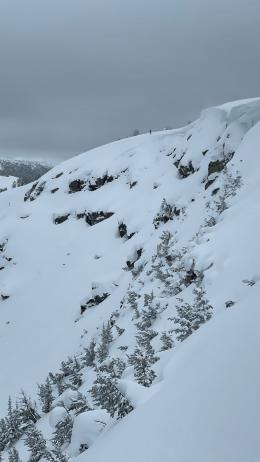
The mountains around Cooke City received about 35” of snowfall measuring 2.9” of SWE. A large avalanche on Wall Mountain was seen yesterday (photo) and a skier reported triggering whumpfs outside town. On Monday, a skier watched a large natural slide release on Woody Ridge (observation and photo). Visibility has been poor and we are unsure of the extent of the avalanche cycle, but today is a day to be extra careful since it’s likely to trigger large avalanches.
Give avalanche terrain a wide berth. Slopes need a day or two to adjust to the heavy snow load.
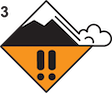
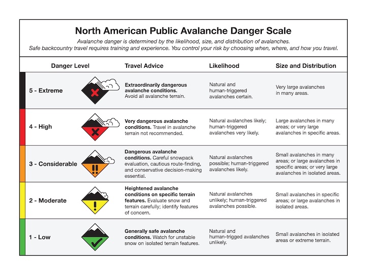
For today, the avalanche danger is rated CONSIDERABLE.

The entire length of the Gallatin and Madison Ranges and the Lionhead area near West Yellowstone received 15-25” of snow with this storm (1.3-1.7 '' SWE). During the storm a skier triggered a slide near Big Sky (photo) and Dave and his partner saw a natural avalanche on Buck Ridge (video). Snowfall stopped and wind is blowing northeast which is stripping many avalanche starting zones. Although natural avalanches are unlikely today, it is still possible to trigger slides in the new snow or on slopes getting wind-loaded. Cracking or collapsing are signs of instability and these slopes should be avoided.
For today, the avalanche danger is rated MODERATE on all slopes.
Please share avalanche, snowpack or weather observations via our website, email (mtavalanche@gmail.com), phone (406-587-6984), or Instagram (#gnfacobs).

In the last few days, Island Park received almost a foot of new snow. Wind has blown this snow into drifts and avalanches are possible on all slopes. Cracking or collapsing are signs of instability and these slopes should be avoided. Always follow safe travel protocols and carry a beacon, shovel, and probe.
Upcoming Avalanche Education and Events
Our education calendar is full of awareness lectures and field courses. Check it out: Events and Education Calendar.
February 24 & 25, Companion Rescue Clinic. Online classroom session Friday evening followed by a field session from 10 a.m.-2 p.m. Saturday. More information and registration HERE.
March 3, 9 a.m.-3 p.m., Bozeman Splitfest - Companion Rescue Clinic. Classroom session followed by a field session. More information and registration HERE.
March 3-5, Bozeman Splitfest. More info and register here.
March 3 & 4, Companion Rescue Clinic. Online classroom session Friday evening followed by a field session from 10 a.m.-2 p.m. Saturday. More information and registration HERE.
March 9, 6 p.m.-7 p.m., 1-Hour Awareness - Spring conditions. FREE at REI Bozeman.
March 10 & 11, SheJumps - Women’s Companion Rescue Clinic. Online classroom session Friday evening followed by a field session from 10 a.m.-2 p.m. Saturday. More information and registration HERE.
Every Saturday, 10 a.m. - 2:00 p.m. Avalanche Rescue Training, drop in for any amount of time. Round Lake Warming Hut, Cooke City. Free.
Loss in the Outdoors, is a support group for those who have been affected by grief and loss related to outdoor pursuits. Check out the link for more information.
On 02/19 an avalanche accident in the Washington Cascades killed 3 climbers and injured 1 on Colchuck Peak. Two members of the party were tucked in the rocks and were not caught. It took all night to alert SAR who are still trying to locate the victims. So far this winter there have been 9 avalanche fatalities in the US.