Good morning. This is Dave Zinn with the Gallatin National Forest Avalanche Forecast on Tuesday, February 21st at 7:00 a.m. This information is sponsored by Highline Partners and onX. This forecast does not apply to operating ski areas.
AVALANCHE WARNING
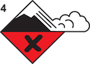
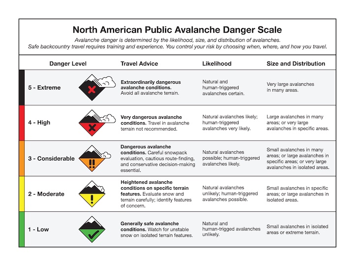
The Gallatin National Forest Avalanche Center is renewing a Backcountry Avalanche Warning for the Bridger Range and the mountains around Cooke City. Heavy snowfall and strong winds in the last three days are creating very dangerous avalanche conditions. Natural and human-triggered avalanches are likely. Avalanche terrain and avalanche runout zones should be avoided. The avalanche danger is rated HIGH on all slopes. Contact the Gallatin National Forest Avalanche Center for more detailed information.
This warning will expire or be updated by 6:00 a.m. on Wednesday, February 22, 2023.
In the last 24 hours, Cooke City received 17” of snow, with 6” in the Bridger Range and 2-4 everywhere else. Temperatures are in the 20s to low 30s F, and winds are blowing 25-35 mph gusting to 55 mph from the west to the southwest. Falling temperatures throughout the day will have us in the negatives F by tonight. Strong winds blowing 30-35 mph from the west to the southwest will diminish this afternoon and shift to the north. Snow continues with 15-20” in Cooke City by tomorrow morning and 4-8” everywhere else.
Avalanche Warning
Very dangerous avalanche conditions exist in the Bridger Range and the mountains around Cooke City. Human-triggered and natural avalanches are likely. Cooke City is getting hammered by new snow with 30” + equal to 2.4” of snow water equivalent (SWE) falling primarily in the last two days. The Bridger Range got a slight break in the last 24 hours, but the webcams at Bridger Bowl show heavy snowfall this morning with nearly 3” falling in the last hour. This adds up to a remarkable 36-40” of heavy snow since midday Saturday (a total of 3.8” of SWE). Winds gusting to 55 mph are adding further weight to slopes and are creating massive overhanging cornices.
New snow and wind-slab avalanches will be large, and we could easily see slides break on buried weak layers deeper in the snowpack and run into flat terrain below. Other than how far they run, the specifics of any avalanche today are unimportant. Anything that slides could be unsurvivable and the strategy is pure avoidance.
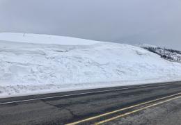
Yesterday, Alex saw multiple slides in the Bridger Range on Saddle Peak and further south, including several on road cuts in the canyon (observation and photos).
Play in the flats away from runout zones, go to the ski area, and enjoy the powder, but DO NOT go onto steep slopes in the backcountry (video).
The avalanche danger is HIGH on all slopes.
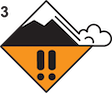
Dangerous avalanche conditions exist in the Madison and Gallatin Ranges and the Lionhead area. Yesterday, at Buck Ridge we saw a natural avalanche in Second Yellowmule that broke about 200 feet wide and 1-3’ deep on a steep, wind-loaded slope. Natural avalanches are free information about instability telling us that human-triggered avalanches are likely, and we should stay clear of steep slopes (video).
The snow totals in the last few days range from 12” (1.0” of SWE) in the Lionhead area to 18-20” near Big Sky and Hyalite (1.1-1.4” of SWE). While the snowfall totals vary, strong wind from last night into this morning is a constant. Wind-loaded slopes with recent drifts are the area of greatest concern for instability, but all steep terrain is suspect. Snowfall continues today and will only exacerbate instability.
New snow and wind-slab avalanches are likely and larger slides breaking on buried weak layers in the upper few feet of the snowpack are possible. Cautious route-finding, careful snowpack evaluation and conservative decision-making are essential.
The avalanche danger is CONSIDERABLE on all slopes.
Please share avalanche, snowpack or weather observations via our website, email (mtavalanche@gmail.com), phone (406-587-6984), or Instagram (#gnfacobs).

Island Park received 8” of new snow in the last couple of days. Strong winds gusting to 55 mph are drifting this snow onto slopes where avalanches are possible. Watch for signs of instability related to wind-loading such as recent avalanche activity, large cornices, and cracks shooting from your sled or skis. Dig a quick snowpit to assess for instability in the upper few feet of the snowpack. Always follow safe travel protocols and carry a beacon, shovel, and probe in case something goes wrong.
Upcoming Avalanche Education and Events
Our education calendar is full of awareness lectures and field courses. Check it out: Events and Education Calendar.
February 19, 10 a.m.-2 p.m. Companion Rescue Clinic Field Day in the Bozeman area. Required Online Classroom Session at 6 p.m. on Feb 18. Information and course registration are HERE.
March 3-5, Bozeman Splitfest. More info and register here.
Every Saturday, 10 a.m. - 2:00 p.m. Avalanche Rescue Training, drop in for any amount of time. Round Lake Warming Hut, Cooke City. Free.
Loss in the Outdoors, is a support group for those who have been affected by grief and loss related to outdoor pursuits. Check out the link for more information.
Bruce Jamieson’s videos on Snow Science explain heady topics to the layman. Understanding the avalanche dragon helps keep us alive.