This is Dave Zinn with the avalanche forecast for Sunday, February 16th, at 7:00 a.m. sponsored by Knoff Group Real Estate, Werner Wealth Management and Bridger Bowl. This forecast does not apply to operating ski areas.
This morning, mountain temperatures are in the single digits to teens F with 10-20 mph winds from the west and northwest. Snowfall increased early this morning, with 2-5” of low-density snow in the last 24 hours, with 6” in the Bridger Range.
Today, high temperatures will be in the teens to low 20s F, with 10-20 mph winds from the west and southwest. By Monday morning, we will see 6-12” of new snow favoring the mountains around Bozeman and Big Sky.
Human-triggered avalanches are likely on steep slopes with fresh drifts of wind-loaded snow in the mountains around Bozeman and Big Sky.
Today's primary concern is wind slab avalanches breaking 1-3 feet deep. The Big Sky Ski Patrol reported rapid wind loading yesterday, triggering many wind slab avalanches during mitigation work. Expect similar conditions in the backcountry today. Recent backcountry avalanche observations include a snowmobiler-triggered slide on Buck Ridge yesterday (details and photo), thin wind slabs triggered by a group up Storm Castle Creek on Friday (observation) and several small wind slabs reported on Thursday in North Bridger Range, near the ice climbs in the Main Fork of Hyalite Creek and on Mt. Blackmore (N. Bridger’s observation, main fork of Hyalite observation, Mt. Blackmore observation).
Storm slab avalanches are a secondary problem. They will break within the layers of new snow as precipitation rates peak. While these will not be as large as wind slab avalanches, both may be large enough to injure or bury skiers and riders. Loose snow avalanches (sluffs) will be dangerous where they can tumble backcountry travels through technical terrain.
Seek out slopes sheltered from the effects of the wind and recognize recent avalanche activity and shooting cracks as critical information about a slope’s instability. Avoid slopes steeper than 30 degrees below cornices and where you observe signs of significant wind loading.
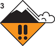
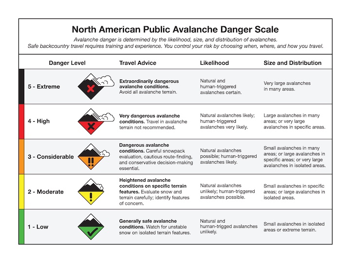
The danger is CONSIDERABLE on wind-loaded slopes and MODERATE on all others.
Three-day storm totals nearing a foot of snow with an inch of snow water equivalent and fluffy snow drifting into unstable slabs create dangerous avalanche conditions on wind-loaded slopes in the mountains around West Yellowstone, Island Park, and Cooke City.
Wind slab avalanches breaking 1-2 feet deep are the primary problem. Yesterday, ski guides working south of Cooke City reported numerous avalanches (photos and observation). With heavier precipitation rates, instability will spread from wind-loaded slopes to all steep terrain in the form of storm slab and loose snow avalanches.
Persistent slab avalanches failing on buried weak layers 2-3 feet deep remain an area of uncertainty. They are most likely on wind-loaded slopes where the snow layer resting on weak layers is thicker and more cohesive. Last week, Alex and I saw four avalanches that broke on layers of sugary facets and feathery surface hoar buried in late January. Avalanche activity on these layers hasn’t been widespread, but activity in the Lionhead area, Cooke City, and Taylor Fork keeps it on the radar.
Avoid wind-loaded slopes where avalanches are more likely and would be larger. Seek out non-wind-loaded terrain, stay alert for signs of instability (recent avalanches, shooting cracks, and collapsing) and dig down three feet to test for instability before committing to steep slopes. The danger is CONSIDERABLE on wind-loaded slopes and MODERATE on all others.
Upcoming Avalanche Education and Events
Our education calendar is full of awareness lectures and field courses. Check it out: Events and Education Calendar
February 18, 3-4 p.m. Whumpfs and Anticracks: the science and mechanics of snow slab avalanches. A free advanced snow science presentation by a visiting professor from Germany at Montana State University in Roberts Hall, Room 101.
February 20, 4-7 p.m. Beacon BBQ at Uphill Pursuits in Bozeman. Come try out different brands of avalanche transceivers (or practice with your own!) with coaching from Friends of GNFAC instructors and free hotdogs.
February 28 - March 2, Bozeman Splitfest 2025 - Celebrate all things Bozeman backcountry and raise funds for GNFAC. Enjoy demos, clinics, free food and beer from MAP. Connect with fellow outdoor enthusiasts and soak up the winter stoke.
Every weekend in Cooke City: Friday at The Antlers at 7 p.m., Free Avalanche Awareness and Current Conditions talk, and Saturday from 10 a.m.-2 p.m. at Round Lake Warming Hut, Free Rescue Practice.