Good morning. This is Dave Zinn with the Gallatin National Forest Avalanche Forecast on Monday, April 10th at 7:00 a.m. This information is sponsored by the Yellowstone Club Community Foundation and Grizzly Outfitters. This forecast does not apply to operating ski areas.
Bridger Bowl Ski Area is closed, and ski patrol is no longer performing rescues and making terrain closure decisions for you (video).
Temperatures are generally in the mid-30s this morning, with only the highest elevations experiencing below-freezing temperatures last night. Winds are 10-15 mph from the west to southwest. Today, highs in the mountains will range from 50 to 60 degrees F with 10-20 mph winds from the south to the southwest.

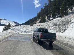
Last night, temperatures remained above freezing in all but the highest elevations. Wet snow avalanches dominate our list of concerns. School bus-sized cornices may collapse, and the snow will get wet early in the day, weakening to the point of failure. By 10:30 am yesterday, we witnessed two wet, loose snow avalanches in Flanders Creek and the upper 6-8” of snow slid cohesively on steep rollovers as we made our exit shortly after noon (video). The Yellowstone Club Ski Patrol observed natural wet snow avalanches on southerly aspects (details). On Saturday, a south-facing avalanche path above Quake Lake buried the highway in wet debris (photos and details). Wet snow avalanches will start earlier and be larger than yesterday. Be off and out-from-under steep slopes before the crust breaks down and the upper 6” of snow turns to mush. Wet snow avalanches can run into the flats, crossing and groomed paths and spilling onto roads.
Dry snow concerns continue with wind slabs and deeply buried persistent weak layers at the forefront. Near Big Sky Resort yesterday, a skier triggered an avalanche that ran full path, the third close call in Lone Lake Cirque in recent weeks (details). Ski patrol observed a recent dry slab avalanche on the Sphinx (details). Last weekend’s storm brought very large avalanches breaking on persistent weak layers buried in January (Northern Madison Range, Southern Gallatin Range, Lionhead, Bridger Range, Bridger Range 2).
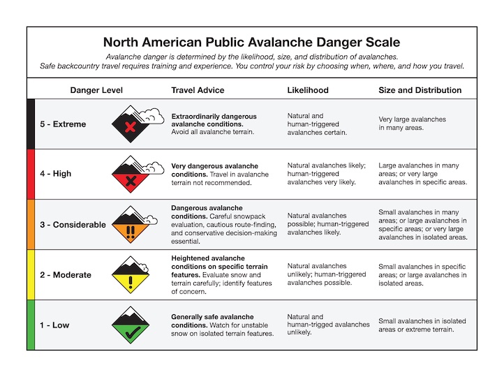
The danger from wet snow avalanches will begin the day as CONSIDERABLE and increase to HIGH. Avoid steep slopes and runout zones as the day warms.

Below-freezing temperatures in Cooke City will delay but not prevent wet snow avalanches. Be off and out-from-under steep slopes by the time the surface crusts break down and the upper 6” of the snowpack gets wet. Avalanches can run into the flats and cross groomed paths. Temperatures pushing near 50 degrees F will weaken cornices and we may see a few collapse today.
Dry snow avalanche concerns remain, including avalanches failing within slabs of recently wind-drifted snow and on deeply buried persistent weak layers. On Thursday, a skier triggered a wind slab on Scotch Bonnet Mountain (details and photo), and avalanches released 1-3 ft deep on wind-loaded slopes (Cooke details 1, Cooke details 2). Deep slab avalanches on Mt. Abundance and on Woody Ridge failed one week ago during a storm. Dig down a few feet to investigate for instability below last week’s snow. Avoid steep, wind-loaded and consequential avalanche terrain to manage deep slab instability.
The avalanche danger is CONSIDERABLE due to the wide array of avalanche concerns, including increasing wet snow danger.
Please share avalanche, snowpack or weather observations via our website, email (mtavalanche@gmail.com), phone (406-587-6984), or Instagram (#gnfacobs).
Upcoming Avalanche Education and Events
Hyalite Canyon road is closed for motorized use until May 16.