Good morning. This is Alex Marienthal with the Gallatin National Forest Avalanche Forecast on Saturday, April 8th at 6:45 a.m. This information is sponsored by Blitz Motorsports and Yamaha and Grizzly Outfitters. This forecast does not apply to operating ski areas.
This morning, there is no new snow, temperatures are high teens to low 30s F, and wind is south-southwest at 15 mph with gusts of 30-55 mph. Today will be partly sunny with temperatures reaching mid-30s to low 40s F. Wind will be out of the west-southwest at 15-30 mph. No significant snow is expected for the next couple days.

Warmer spring weather brings a diverse list of avalanche concerns this weekend. Wind slabs and persistent weak layers remain reactive, and wet loose avalanches are possible.
A person could trigger large to very large avalanches that break below the snow that fell last weekend, or several feet deep on weak layers that were buried in January. On Thursday, near Cooke City a skier triggered a wind slab on Scotch Bonnet Mountain (details and photo), and in the northern Gallatin Range a snowmobiler triggered a 1 foot deep wind slab (details and photos). Slides also broke 1-3 ft deep on wind-loaded slopes near Cooke City and in the Bridger Range (Cooke details 1, Cooke details 2, Saddle Peak details). Assess for recent wind-loading and dig down to investigate the top couple feet of the snowpack for instability before riding steep slopes.
Huge deep slab avalanches have occurred since late February, and we’ve had reports of many monster slides that broke after last weekend’s snow. Yesterday, skiers reported recent deep slabs in the Northern Madison (details and photos) and Southern Gallatin Ranges (details and photos). We also know of big avalanches that occurred last weekend near Lionhead, Cooke City, and in the Bridger Range. These deep instabilities are difficult to test for, so your best bet is to avoid steep slopes entirely. If you accept the low likelihood, high consequence risk and venture into steep terrain, hedge your bets by choosing terrain with less wind-loading and without the consequences of trees or cliffs.
Last night’s below freezing temperatures allowed yesterday’s wet snow surface to refreeze. Wet snow avalanches will become more likely as the snow surface softens and loses strength later in the day, especially on sunny slopes. A few may release naturally around rocky outcrops on slopes that face the sun. Anticipate wet loose slides to occur when the upper few inches of the snowpack become soft and wet. Be alert for quickly changing conditions and plan to be off and out from underneath steep, sunny slopes when you notice the snow surface starting to melt.
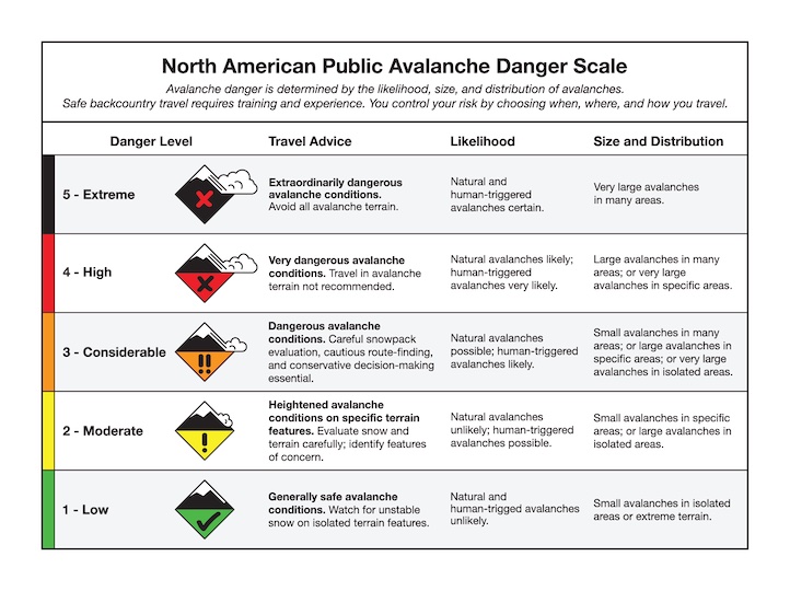
A wide range of avalanche concerns make human triggered avalanches possible, and today the avalanche danger is MODERATE.
Our last daily forecast will be this Sunday, April 9. We will issue weather and snowpack updates every Monday and Friday through April. Please share avalanche, snowpack or weather observations via our website, email (mtavalanche@gmail.com), phone (406-587-6984), or Instagram (#gnfacobs).

Warmer spring weather brings a diverse list of avalanche concerns this weekend. Wind slabs and persistent weak layers remain reactive, and wet loose avalanches are possible. Assess for recent wind-loading and dig down to investigate the top couple feet of the snowpack for instability. Deeper instabilities are difficult to test for, so your best bet is to avoid steep slopes entirely. If you accept the low likelihood, high consequence risk and venture into steep terrain, hedge your bets by choosing terrain with less wind-loading and without the consequences of trees or cliffs. Be alert for quickly changing conditions and plan to be off and out from underneath steep, sunny slopes when you notice the snow surface starting to melt.
Upcoming Avalanche Education and Events
Hyalite Canyon road is closed for motorized use until May 16.