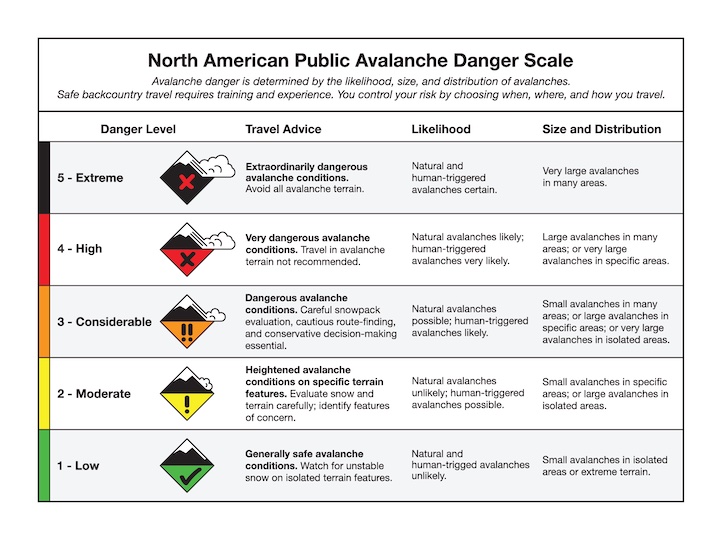
Good morning. This is Doug Chabot with the Gallatin National Forest Avalanche Forecast on Wednesday, January 11th at 7:00 a.m. This information is sponsored by onX and Archer Construction. This forecast does not apply to operating ski areas.
At 5 a.m. it is currently snowing around West Yellowstone (4” of new) and Taylor Fork (1”). Wind is blowing east across our forecast area which is an unusual direction. Wind speed is 5-15 mph with the Bridger Range getting gusts of 25 mph. Today the mountains around West Yellowstone will get 3” with 1-2” falling everywhere else. Temperatures will remain in the high teens F. Wind will shift to the southwest in the southern ranges today and remain easterly elsewhere at speeds of 10-15 mph.
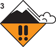
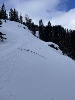
The mountains around West Yellowstone got a foot of new snow since Sunday. This load was added incrementally, but last night's snowfall and more falling today will elevate the avalanche danger. A weak layer of surface hoar (feathery crystals) is buried a foot under the surface and is likely to be triggered. Weak layers of sugary facets deep in the snowpack could also be triggered from either thinner spots where it's easier to impact this layer or from a smaller avalanche. Dave explains the layering in his video from Monday. Today is a day to avoid avalanche terrain. Whumpfing or collapsing of the snow and recent avalanches are clear signs of the widespread danger. For today the avalanche danger is rated CONSIDERABLE on all slopes.

The southern Madison and southern Gallatin Ranges and the mountains around Cooke City have weak layers of snow that could avalanche. The most sensitive is a layer of feathery surface hoar crystals buried up to a foot deep. Yesterday, we found it breaking easily in Cooke City (video) and on Monday Dave got similar results in Taylor Fork (video). The good news is that it is shallowly buried and easy to find with stability tests. The bad news is that it is sensitive, not found everywhere, and may not be visible to the naked eye. This layer is our primary concern right now, but weaker snow lower in the snowpack is also worrisome, especially around Cooke City where natural and human triggered slides are still occurring. Our Weather and Avalanche Log and Avalanche Activity pages have details. Recent activity and poor stability test scores are evidence that it is possible to trigger avalanches today. At a minimum, dig and test for the surface hoar. If you get into avalanche terrain, stack the deck in your favor and only expose 1 person at a time and carry essential rescue gear (beacon, shovel, probe). For today the avalanche danger is rated MODERATE on all slopes.
The mountains around Bozeman and Big Sky have not gotten much snow, but they had human triggered avalanche activity over the weekend around Big Sky (First Yellowmule, BS sidecountry and Buck Ridge), and on Friday a large avalanche on Saddle Peak was likely triggered by skiers kicking a cornice. Avalanche activity along with a poor snow structure (weak layers tenuously supporting denser slabs) mean it's still possible to trigger avalanches (Dave’s video from the Bridger Range). The weekend’s activity is recent enough to serve as a warning. Lives can be saved by carrying rescue gear and traveling one at a time in avalanche terrain. The avalanche danger is rated MODERATE.
Please share avalanche, snowpack or weather observations via our website, email (mtavalanche@gmail.com), phone (406-587-6984), or Instagram (#gnfacobs).

The mountains around West Yellowstone and Island Park got a foot of new snow since Sunday. This load was added incrementally, but last night's snowfall and more falling today will elevate the avalanche danger. Yesterday sledders triggered a slide near Mt. Jefferson. Today is a day to avoid avalanche terrain. Whumpfing or collapsing of the snow and recent avalanches are clear signs of the widespread danger.
Upcoming Avalanche Education and Events
Our education calendar is full of awareness lectures and field courses. Check it out: Events and Education Calendar.
Thursday, Jan 12th, 6:30 p.m., 1hr avalanche awareness for mechanized users at BSCO BASE in Big Sky. Free.
Every Saturday, 10 a.m. - 2:00 p.m. Avalanche Rescue Training, drop in for any amount of time. Round Lake Warming Hut, Cooke City. Free.
Loss in the Outdoors, is a support group for those who have been affected by grief and loss related to outdoor pursuits. Check out the link for more information.
On Saturday in Colorado, two snowmobilers were caught, buried, and killed in a large avalanche on the east face of Mount Epworth, about 6 miles east of Winter Park. Grand County Sheriff's Deputies and search and rescue were unable to locate the second rider before dark, but found the second rider deceased yesterday. (Preliminary report).