Good Morning. This is Doug Chabot with an early season avalanche information bulletin issued on Monday, November 22 at 7:30 a.m. This is sponsored by Team Bozeman in partnership with the Friends of the Avalanche Center. We will put out another bulletin tomorrow and Wednesday morning, shifting to non-stop daily advisories on Friday. Please remember that uphill traffic is not allowed at Big Sky or Moonlight Basin Ski Areas. Bridger Bowl is not open and has backcountry snow conditions.
Last night 3-6” fell in the southern mountains with a trace to one inch dusting the northern ranges. Winds were remarkably still yesterday, but recently picked up to 10-20 mph out of the west-southwest. Mountain temperatures are in the single digits in the north and in the mid teens down south. There won’t be much warming today as temperatures drop to 10 below tonight. A moist flow will bring snow showers today through Tuesday. The southern mountains should see 4-6” by tomorrow morning with 2-4” falling in the north (Big Sky to the Bridger Range).
An honest three to four feet of snow is blanketing our forecast area. The snowpack around West Yellowstone and Cooke City doubled in depth this past week and will likely get deeper with this week’s storms. Over the weekend there were many sluffs naturally releasing and running long distances. Wind slabs were noted on the ridgelines throughout the north, but generally these stayed put. Skiers in Beehive Basin saw widespread wind slabs in the upper elevations and chose to stick near treeline.
In the northern Madison, northern Gallatin and Bridger Ranges we are finding common ground with our stability assessments. First, stability tests in snowpits are not showing fractures consistently propagating (a good sign); however, there does seem to be lingering weakness at the October/November interface. This is marked by an ice crust on some slopes. Skiers in the northern Bridgers found this yesterday while a reliable observer in Beehive Basin did not. At higher elevations the Big Sky Ski Patrol was able to release avalanches on this layer with explosives. Our second concern is the wind slabs near ridgelines which skiers might still be able to trigger. These are specific to ridges and easy to find and avoid. Our third concern is the poor bonding with the new snow since Friday which readily sluffed long distances. I saw this in the Bridger Range on Saturday, plus climbers reported gullies spewing windblown snow up Hyalite. The danger with sluffs isn’t burial as much as pushing you off balance and carrying into nasty terrain. The snowpack isn’t perfect, but it’s generally strong. I’m hoping it stays that way since prolonged frigid temperatures can turn powder into sugary facets quickly; a weak layer to be reckoned with. We have no field data from the southern mountains yet so I recommend conservative decision making if you’re heading in to the backcountry. We will begin issuing avalanche danger ratings as we get out in the field and assess the stability more thoroughly. Eric will issue another Avalanche Information Bulletin tomorrow morning and again on Wednesday. Daily advisories will start on Friday. If you have any snowpack or avalanche observations, drop us a line at mtavalanche@gmail.com or call us at 587-6984. Upcoming Avalanche Education Basic Avalanche Awareness – Wed & Thurs, December 1 & 2, 7:00pm – 9:30pm at SUB Ballroom B&C; 12/4- Field day at Bridger Bowl (more information) (Prepay $25 fee) Avalanche Awareness for Snowmobilers – Wed & Thur, December 1 & 2, 7pm – 9:30pm at Team Bozeman, 2595 Simmental Way (more information)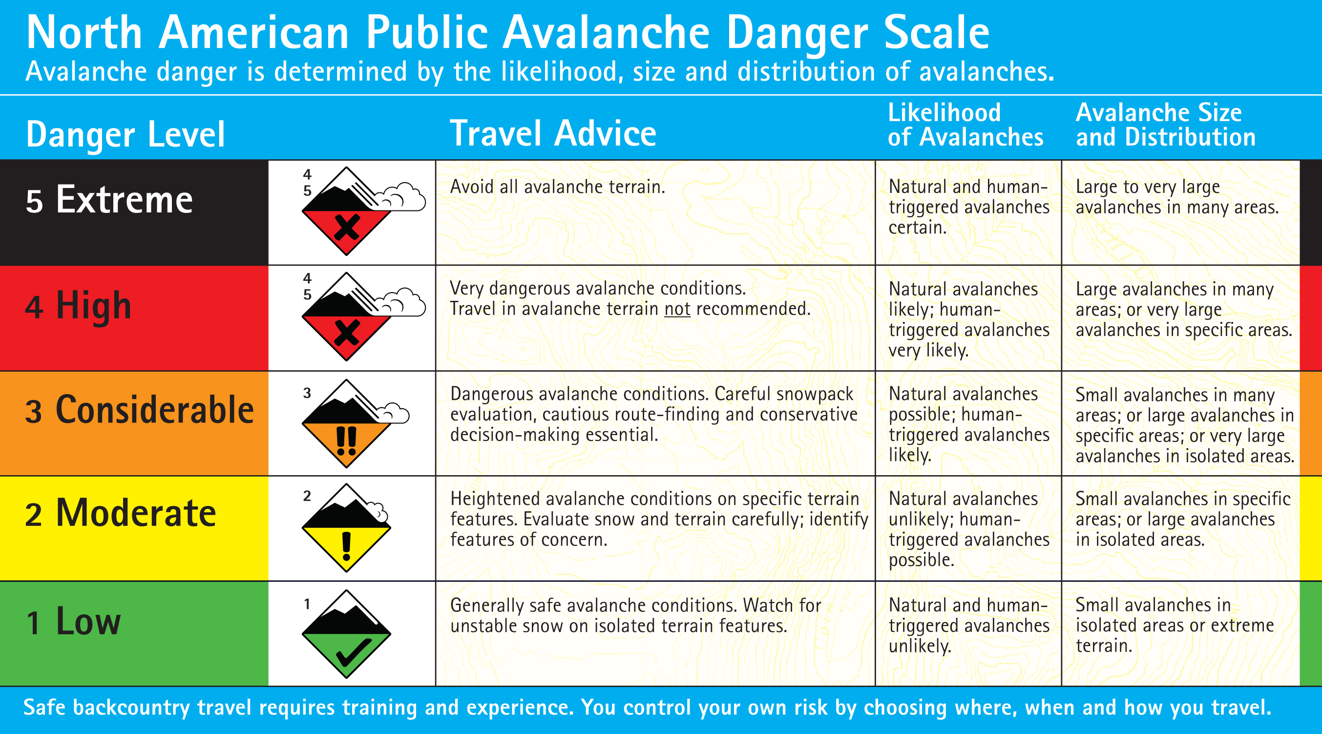